October 28, 2024
Skiing Inside a Volcano in Japan: Hiking Mt. Yotei
Hiking Mt. Yotei without a guide
By Rob Baney
By now, the top can’t be more than a hundred vertical meters above. I struggle to even dent a foothold into the wind-swept mounds of ice as I attempt to make the next step. My only handholds are small, twisted trees that cling defiantly to the scoured rock face as I’m hiking Mt. Yotei.
My body and mind are increasingly weary. Each time I look up to where I can see the snow and ice meet the sky above me, I pray it is the very top – the summit I have been longing to reach for over six hours now. Knowing I am so close, I begin to imagine the thirst-quenching cup of tea and appetizing pre-made meal of spaghetti and meatballs that I will treat myself to at the top.
However, whilst I fantasize, I am swiftly reminded that any lapse in concentration results in a clunk to the back of the head from the skis strapped to my backpack. My foot slips into a tree-well. On all fours, I scramble up a few more meters, forcing myself back to my feet. I climb up to the next ridgeline, now the third, which I had wholeheartedly believed to be the top. It wasn’t. But to my relief the summit is now finally in sight.
The hard part is over. I can see people milling around, relaxing and chatting just a few strides above. For the final twenty vertical meters, the incline is far less strenuous. Less than five minutes later, I am finally at the summit of Mt Yotei.
Hiking Mt. Yotei in the Snow
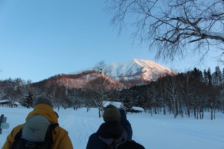
Mt. Yotei is a dormant volcano that sits at the heart of southwest Hokkaido. At an elevation of 1898m, it towers over the world-renowned ski resorts of Niseko and Rusutsu, famous for their powder snow. You can find out more about it here. Its resemblance to Mt. Fuji is uncanny. So much so, that it is also known as Ezo Fuji – ‘Ezo’ being an old word for the island of Hokkaido. On the few occasions that it is unblemished by cloud and displayed in all its glory, it is a mesmerizing natural attraction and an enticing challenge to any ambitious hiker.
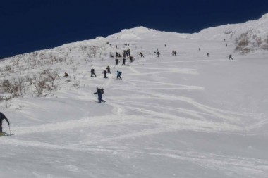
The false tops and negative thoughts on the way up blissfully transform into a rush of endorphins and a sense of achievement once atop the mountain. A euphoric atmosphere radiates around the dozens of people who have also chosen today as the day to climb Mt Yotei, with strangers congratulating each other on summiting.
It is no coincidence we are all up here today. The conditions are almost perfect; there is a barely a cloud in the sky, and the winds are hardly more than a breeze. There has been recent snowfall, but enough time has passed for the new layer to consolidate and the avalanche risk to be low. It is the first day of the season, and the weather has been so ideal for summiting. Nothing signified this better than the ant trail of hikers marching up from the Makkari route.
Pick the Right Day
Picking the right day to attempt Yotei is the first thing to consider. Check the weather and mountain forecasts. Look for a day or two with low winds and clear skies, and earmark those days in advance (though you won’t know for sure until a day or two ahead of time). Check online (http://niseko.nadare.info) for avalanche information on Niseko. Bear in mind there are no avalanche reports for Mt. Yotei, but the Niseko reports will give you a good indication of the risk level.
The Makkari route, on the south side of Mt. Yotei, is the most common hiking route and is recommended for less-experienced climbers. There is an easily accessible car park at the bottom, and the hike is the most mellow. There is no designated trail to follow to the summit, so it is essential to have a meticulously planned route using Google Maps and various topography maps.
The Risk of Avalanches
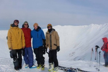
Our group certainly fell in the inexperienced category. All four of us had completed an avalanche course a month earlier, but it was the first time we had used ski-touring equipment, learning about avalanches and how to find a transceiver buried in the snow. Mt. Yotei was our first-time backcountry touring without a guide.
We started hiking at sunrise and were fortunate to have a track to follow. Sam and I had been up to the tree line on our avalanche course so we knew the route we wanted to take. Early on, we made the mistake of dilly-dallying, taking too many pictures, and sympathizing far too much with our friend Henry, who was nursing nothing more than a mild hangover. It should go without saying but drinking anything alcoholic the night before is not recommended.
After that, we made reasonable progress until brunch. Henry lagged behind the rest of us, but there was no issue; we had plenty of time. Yet the gradient began to steepen; we could no longer use skis to hike up. It was then that we had to boot-pack, proceeding on foot with our skis strapped to our backpacks. This is when we encountered our first serious problem.
Sam, still hiking up on skis, 100 vertical meters below me, suddenly found his binding had become detached. I was unsure if he could continue. We were so close that the thought of turning back created a real dilemma for me.
“Summit Fever”
I knew if Sam asked that I should turn around, but at that moment, I couldn’t say for sure that I would have joined him before summiting myself. I have since ascertained that this irrational state of mind is known as ‘summit fever:’ a compulsion to reach the summit at all costs. Thankfully, Sam quickly chucked his skis on his back and began boot-packing. The dilemma was resolved.
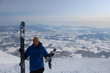
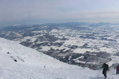
The view from the summit is stunning. The sea is visible in both directions: the Sea of Japan to the north and Uchiura Bay to the south. In between the two are the rolling peaks of the Niseko-Annupuri mountain range, including Mt Usu, an active volcano that separates the idyllic Lake Toya and the sea, and Mt Shiribetsu, a dainty mountain known as Mt Yotei’s wife.
Once we polished off our pre-prepared meals and finished snapping photos, we focused on skiing the crater. Sam sensibly opted out of the crater lap and got help from another summiteer to get his binding into a ski-able state. Henry calculated that a crater lap equals more hiking and decided to keep Sam company.
The Descent
So it was down to Tom and I, picking our line down before traversing a quarter of the crater ridge to our starting point. We dropped a small cornice before skiing into the bowl-shaped crater. The snow was no more than shin-deep, but it was so light and soft that it felt like we were floating down. At the bottom, all you can see is a surrounding colosseum of sharp spines of snow and a blue sky above. To be standing in the middle of a volcano crater felt unimaginably surreal. It is so peaceful, so it’s hard to fathom that thousands of years ago, it would have been filled with lava, ready to erupt.
After hiking out of the crater, the final task was to get back down to the car in one piece. Skiing down is meant to be the easy part. But we had to keep our wits about us, having slightly lost our bearings after the crater lap. Wisely, we checked the photo we had taken in the car park, looking up at the route. We located ourselves and the valley we needed to follow and chose our way down. The skiing was fantastic; steep open gullies with sublime dry powder snow were above the tree line. But it wasn’t until we were in the trees that we truly started to relax as we cruised down to the car in the shallower terrain.
At the bottom, we laughed, smiled, and shared a few labored fist pumps. Our contrasting emotions of happiness and exhaustion epitomized the incredible experience of the day. It was not without incident, but it was a day to remember.
Want to attempt hiking Mt Yotei? Here is what you need:
- The right day – low avalanche danger, low winds, and clear skies is the optimum day to aim for. They should be prioritized in that order.
- Avalanche safety gear – transceiver, probe, shovel. As well as have it, you need to be competent with all of it.
- Meticulous planning – make sure you know where you are going. Don’t rely on other people’s skin tracks – they may know no better than you. Always have a turnback time strictly set in place.
- An extra layer – it is extremely cold at the summit, even with low winds.
- A touring setup: Skiers – Alpine touring bindings (compatible with Alpine boots) or touring boots and touring pin bindings; Snowboarders – split board or snowshoes.
- Climbing skins – nylon or mohair strips that are fitted to the shape of your ski or splitboard.
- Plenty of liquid.
- A sense of humor – it can be painful, but it is fun, so enjoy it!
If you love winter activities, check out our guide to 8 Lesser-known Ski Spots Close to Tokyo.
Editorial note: This article was originally published on April 19, 2017, and has been updated on October 28, 2024, for clarity and flow.