March 11, 2010
Map
Originally published on metropolis.co.jp on March 2010 Though some would argue that GPS has rendered paper maps obsolete, many others—especially the kanji-challenged among us—will appreciate Informa’s cleverly designed Tokyo guide. Stations like Shinjuku that serve as central transfer points are indicated with a larger icon than their lesser-used neighbors, while pedestrian transfers like Hibiya/Yurakucho or […]
By Metropolis
Originally published on metropolis.co.jp on March 2010

Design and Conception by Vollmer Design Tokyo. © 2008 - 10. All Rights Reserved
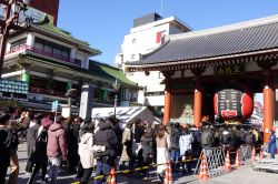
Though some would argue that GPS has rendered paper maps obsolete, many others—especially the kanji-challenged among us—will appreciate Informa’s cleverly designed Tokyo guide. Stations like Shinjuku that serve as central transfer points are indicated with a larger icon than their lesser-used neighbors, while pedestrian transfers like Hibiya/Yurakucho or Harajuku/Meiji-Jingumae are also clearly indicated. The bilingual map is color-coded to show rivers and green spaces, and eye-catching icons at major tourist spots—a temple at Asakusa, for instance, or a fish at Tsukiji—are also included. The map is available online (¥360 + shipping) and at local retailers like Kinokuniya, National Azabu and Aoyama Book Center.